
Day 36: Charleston to Lyell
Journal for 2014-11-25 | Published on 2014-11-27 00:43:43Woke up this morning, and the fog had rolled in. The mountains we could see yesterday were shrouded in white clouds, and a fine mist was falling. We followed our usual morning routine of oatmeal, dishes, get dressed, and head out. The owner asked which way we were heading, and when we said “east” she said, good, because bad weather is headed for the south. Whew!
On the road, and a couple of bigish climbs later, we passed the hostel we had been shooting for last night. I’m glad we stopped where we did, because we got pizza for dinner, for one, and it would have been a long 5 km climbing up to that place last night.
Since we didn’t know exactly where we were on the map, our estimation of where the Westport junction was off by about 8 km, so that meant our ride for the day was going to be a little longer than anticipated. Our ride consisted of climbing the Buller Gorge, following the Buller River, and we weren’t sure what that would entail. We’ve followed rivers where the road gently climbs, and we’ve followed rivers where the road climbs up and down steep bluffs. Which would this one be?
Thankfully, the lower gorge road followed a very gradual incline, with just a few hills. It was so gradual that sometimes I forgot we were climbing! It was so beautiful, even with the clouds, the rock walls of the gorge closing in, the rushing river flowing past, the streams and rivers flowing into it. Unfortunately while pausing for a snack break we found that hundreds of sand flies cover every meter of it and we had to quickly eat before they sucked us dry.
Continuing to pedal along we admired waterfalls along the way, and wildflowers (probably noxious weeds, but still pretty), saw a big hawk take off, saw many weka and pukeko, heard songbirds. It was a very pleasant ride.
Just about the time we were starting to get hungry for lunch, a fortuitous sign appeared: Berlins Café: Open. Just around the corner was the café, and we went inside to check it out. Reasonably priced burgers, we ordered two, and looked at the memorabilia around the room. There was a gigantic mortar shell on display, and there were newspaper articles explaining that it was found in the front step of the café when they were renovating, a bomb squad detonated it, and they put the pieces back together so they could display it. At first thought to be from the First World War, but dated much earlier to the Maori Wars, in the 1860s. Fascinating piece of history right under their front door step all those years!
Full on burgers and chips, we set off, thinking we probably had about 10 km to go. We made it to the junction, where we would have come from if we had headed east from Greymouth instead of north. Then, hoping for an ice cream in Inanugahua, we rolled into town to find it deserted, and most of the buildings for sale. There was an informative local history museum open, however, and we amused ourselves for a while, reading stories, newspaper accounts, and looking at photographs of the area. No ice cream, but we did read about a woman, Old Biddy, who was a gold miner in the area, along with two of her good male friends. She was quite a character, spending most of the gold she found on whisky and tobacco.
On the way we went, and whoever measured the distance from the campsite we were heading toward and the town sure did an awful job. It should have been 10 km, but was closer to 15 km. Of course it started raining in the last km, but we didn’t want to stop long enough to put on the rain gear. The campground is a DOC site, which means no showers and just a pit toilet, but it’s in a really pretty spot, and we pitched our tent under a tree so we should avoid getting too wet.
We cooked dinner, and some passing tourists asked us questions. They also were from Los Angeles. Small world, sometimes! The sandflies are out in droves, so we ate while walking. Seems to be about the only thing that keeps them from biting is movement. We did some after dinner exploring, and now we’re in the tent trying to keep the sand flies at bay. It was a beautiful ride up the Lower Gorge, I’m interested to see how the Upper Gorge compares. Hopefully we’ll complete it tomorrow.
Distance: 73.4km
Time: 4:42
Average: 15.6kmh
Max: 46.6kmh
Climb: 771m
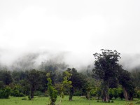
Forest cloaked in clouds
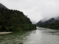
Buller River and Gorge
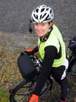
Pam helping me balance on something get just the right picture
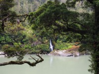
One of many waterfalls we saw today
0 guestbook posts. Click here to post one.