
Day 2: Christchurch to Glentunnel
Journal for 2014-10-21 | Published on 2015-08-23 00:10:07We started off the day at Biffy’s house in Christchurch at a leisurely pace. We made ourselves some breakfast of oatmeal and then partook of some more breakfast when Biffy made some toast and tomatoes. Eventually we said our goodbyes and headed over to a sporting goods store to buy camp stove fuel.
Embarking on our first ride on the left hand side of the road adventure would have been comedy to any nearby pedestrians. First Matt started riding down the wrong side of the road, then at every intersection we were very vocal about what we were doing “I am looking right and then left”, “this left hand turn is so much easier”, “oh no this right hand turn is crazy!” Besides being nerve wracking for most of the day it really wasn’t that difficult.
We headed out of Christchurch on a cycle path around the airport and in to McLean’s Island. At another time I am going to have to look up why it is called McLean’s Island, there doesn’t appear to be an island, nor do I know who Mclean was.
Eventually the bike path ended and we rode on mostly quiet roads for a good while. The day was perfect with cool air and warm sunlight. The scenery was nothing terribly exciting as we are on a large plain (the Canterbury Plain) with some mountains in the distance.
We had our first snack break of the day (nuts and jerky) near an animal park, and we peeked through the fence to see emus and other exotic birds.
Our second snack of the day was an apple (a New Zealand Rose, crisp and tart and a little sweet. A very nice apple!) enjoyed on the side of the road with the sun shining, the birds chirping, the sound of a stream nearby, and insects buzzing. Pam closed her eyes and just absorbed all the sounds of nature while feeling the warmth of the sun on her face. It is an amazing thing to be out on a tour again.
All day we’ve been passing through little towns, some are just a group of houses and a sign, others are a bit bigger with convenience stores. We’re still learning to recognize different kinds of stores, and what their purpose is.
After a little lunch break and some snacks we made our way in to our first large town outside of Christchuch, Darfield. We ran into a grocery store to get some supplies.
We had been going slowly all day, but after Darfield we both were really dragging. We had planned to make it Raikia Gorge but ended up stopping in Glentunnel at the Holiday Park. The park is nearly empty, as it is a weekday and still the off season. Labor Day is Monday so we’ll likely have more traffic over the three day holiday weekend.
After showering we walked down to the river and watched the crystal clear water wash by. There were several little red birds flying around doing acrobatics, including getting with a few meters of us. We watched them for some time and realized they were catching small flying insects by changing directions mid-flight and grabbing them out of the air.
Our lack of training before this trip has contributed to our small number of km traveled today, but we’re just out here to enjoy it. And we sure are enjoying it. The freedom of the road, the nice people we meet (a fellow cyclist stopped to chat with us, asked us where we were headed, and offered up a bunch of advice. It’s people like him that make me enjoy touring so much.)
One thing that Pam is finding amusing is the difference in signage between NZ and the states. For example, in the states, if there’s a truck with a wide load, a car typically drives in front with a sign that reads “Wide Load.” Here, the sign reads “Wide Load Follows.” Yield signs are “Give Way.” It’s a “Rail Way Crossing,” not “Railroad”. Blind driveways are “Concealed”.
Distance: 65 km
Time: 4:04
Climbed: 294m
Max Speed: 24.2km
Avg Speed: 15.9km
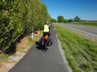
Pam riding the bike path out of Christchurch
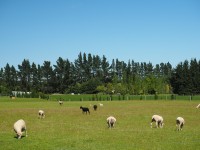
Did you know that there a few sheep in New Zealand?
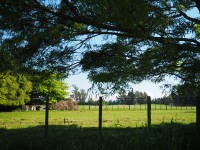
A spot for lunch.
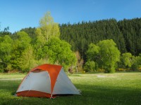
Camping at Glentunnel Holiday Park
| Statistics | ||
|---|---|---|
| Type | Today | |
| Distance (km) | 65 | |
| Climbed (m) | 294 | |
| Maximum Speed (km/h) | 24.2 | |
| Average Speed (km/h) | 15.9 | |
| Time Riding (hrs) | 4.12 | |
| Average Speed (mp/h) | 99 | |
Wow, You guys are great. I am glad you are taking time to enjoy the trip not just put in the miles. If the picture you posted is representative of where you rode, it must have been a very nice ride. peace and love, mom
During the 1930s, under employment schemes, hundreds of men armed only with shovels, picks and wheelbarrows created stopbanks and groynes along the river. The original pine plantations along the river were also planted during the 1930s Great Depression. Later Miners, Harewood and McLeans banks blocked off the south channel so that the river was shifted to the north side of McLeans Island. The South Branch of the Waimakariri became the spring fed Otukaikino Stream which we enjoy today at the Groynes Picnic Area. From: http://ecan.govt.nz/publications/General/mcLeans-island-brochure.pdf